 |
|
|
| Distance : 16 miles | Grading : +++++ | OS Sheet : 126 |
This is perhaps the longest, toughest and most spectacular walk along the South West Coast Path. It begins from the remote Hartland Quay and follows the coast south for around 15 miles to the popular resort of Bude. On the way you will climb to the top of the cliffs and then back down to sea level many times, but this makes for some spectacular scenery and numerous waterfalls. The walk passes through no villages or towns on the way and so is very remote and you should therefore ensure you carry enough water and food with you.
This walk begins from Hartland Quay, some distance from Hartland. From the A39 (Atlantic Highway) if heading west from Barnstaple and Bideford, turn right onto the B3248 just after the turning for Clovelly at Clovelly cross and follow this road into Hartland. From the south take the left turn onto the B3248 when signed, around 12 miles north of Bude and around 3 miles before Clovelly. Once in Hartland if coming from Barnstaple and Bideford continue straight on along the road, signed for Stoke. From the south, on reaching the square take the road to the left, signed for Stoke (there is a small one way area). This road has some single track sections and one steep hill, so care is needed. You pass the entrance to Hartland Abbey on the right and keep going into Stoke, with it's very tall church tower. Go straight on here, with the church to your right and continue along the road (signed for Hartland Quay). The road descends to the quay and hotel. The last 1/4 mile of the road is private and you must pay a toll to use it (£2 at the time of writing). There is a free car park just above the hotel or another at lower level, but this may be reserved for users of the hotel or pub only so do check first.
Due to the remote location, public transport access for this walk is difficult. There is a bus service to Hartland from both Barnstaple and Bideford and a less frequent service from Bude. From Hartland you'll need to walk along the road to Stoke (there is no pavement, but generally there is not much traffic) and continue along the road to Hartland Quay. In total you'll need to walk a little over two miles from Hartland to reach the start of the walk. You may prefer to call a taxi - one of the pubs or shops in Hartland should be able to provide a number, but this may be costly, as I don't believe there is a taxi firm based in Hartland.
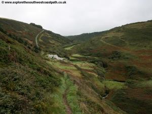
The nearest accommodation to Hartland Quay is the Hartland Quay Hotel, right on the coast path. There is a large camp site and bed and breakfast available at Stoke Barton Farm, around half a mile from Hartland Quay and accessible via footpaths across the fields (it is signed from the coast path, just aim for the tall church tower and stick to the mowed paths over the fields). Otherwise there is a slightly larger choice of accommodation in Hartland or Bude.
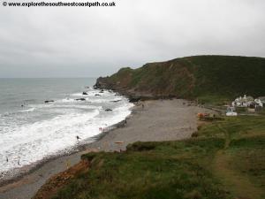
Hartland Quay is a spectacular and remote location. The hotel here includes a pub and a ship wreck museum and there is a small shop and toilets opposite. Be warned that there are no facilities along the coast path all the way to Bude and it is a hard walk, so be sure to stock up (if the shop or pub are open!). Hartland Quay itself no longer exists. When the railway arrived in Bideford, and road links improved, the cost of maintaining the quay at Hartland against the enormous forces of the sea here meant the quay was no longer feasible and now only the pub and hotel remain.
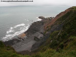
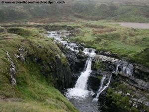
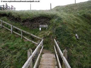
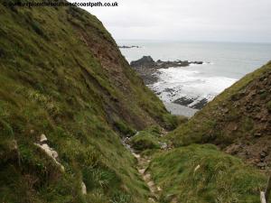
From the car park head up the steps and then turn right. You come to a small valley where you head briefly inland crossing on a little bridge and then returning to the coast. Head south past Screda Point and Screda Cove along the valley edge to come to a small waterfall. You'll see many waterfalls on this walk, but the best is yet to come, though this is a very beautiful spot. The coast here is unusual with a tall hill forming a cliff to the right, but rather than climb it the coast path goes round behind it. Keep heading south, with the coast to your right as the path climbs round the bay of Speaks Mill Mouth and descends the other side to a spectacular pair of waterfalls, Speakes Mill Mouth.
In order to cross the stream you then need to follow the north side of the river east until you can cross via a wooden bridge. Once across there are two possible routes. The official route heads below the top of the cliffs Swansford Hill therefore not offering coastal views. An alternative path goes up onto the top of the hill, but is quite steep and narrow, both end up in the same place so you can choose which ever route you prefer. You come to the cliff top above Hole Rock and continue south along field edges of this gently undulating coast, passing Mansley Cliff. Just south of here the path goes between two fields (a smaller on the right) and on reaching a junction of paths you turn left (away from the coast) rather than right as you might expect to join a minor road. Turn right and follow the road for around a quarter of a mile where you turn right on a path and back to the cliff top.
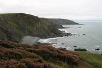
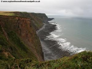
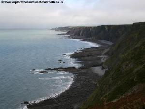
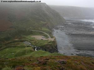
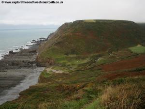
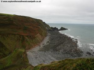
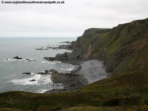
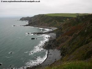
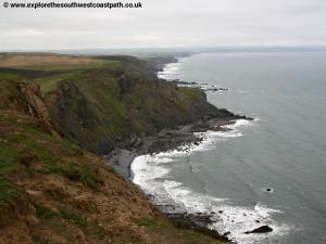
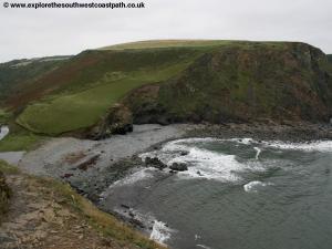
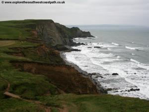
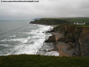
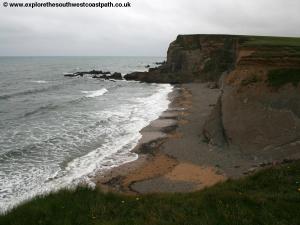
For the next couple of miles you really can't go wrong as the coast path sticks right to the cliff top pass Broadbench Cove and on to the top of Embury Beacon an old hill fort which offers beautiful views, particularly to the north back along the coast to Hartland Quay. The path descends gently past Newthorne Beach (which cannot be accessed, as there is no path down) to Knap Head, another head land offering fine views both north and south. From here you descend steeply down to another valley, Welcombe mouth. Here there is another waterfall which although not as large as those at Speakes Mill Mouth is still impressive. This waterfall tends to be more visited, as there is a small car park here. There is also a rocky beach which offers a small amount of sand.
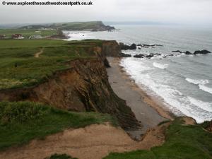
This time you cross the stream via a few large round stepping stones and then you have another steep climb to the top of the cliffs then almost immediately another steep descent into the next valley. On the way down you pass Ronald Duncan's hut where the playwright and poet used to write. The hut is often unlocked and you are invited to go inside and look round. Continue your steep descent down to the next valley, Marshland Mouth where you cross the little stream via a wooden footbridge and in doing so you cross from Devon into Cornwall. Here you head a little inland to begin the climb up the next cliff where you have fine views back to the pebble and rocky beach at the mouth. The path now heads out onto the headland to the south offering fine views back to Welcombe Mouth. The headland is a low rocky headland with an arched rock although there is not a path along it. Beyond you have another steep descent down to Litter Mouth.
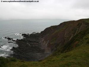
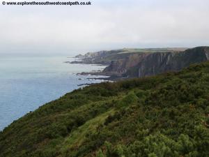
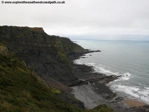
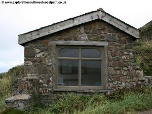
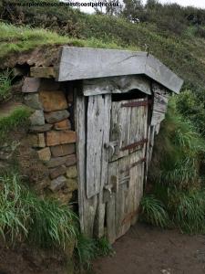
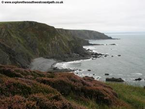
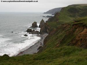
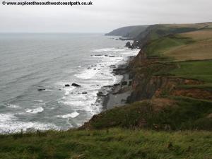
You cross the stream and climb back up another steep climb to Cornakey Cliff from where you have views back to the Gull Rock and can see the rocky arches in it. Ahead you have another descent down to sea level to Yeol Mouth where there is another waterfall. Beyond, you climb back up to the 140m high Henna Cliff where you are rewarded with fine views of the surrounding coast. Just beyond, once again, you descend back down to sea level to another valley with a waterfall. Cross the stream via a footbridge where you have another steep climb back up Vicarage Cliff from where you have views of the village of Morwenstow and it's church tower. If you are shattered by this stage there is a twice daily bus service from here to Hartland and Bude (except on Sundays). After reaching the top of the cliffs look out for the path down to the National Trust owned Hawkers Hut. This unusual hut was built by the vicar of Morwenstow out of drift wood and he used it as a little retreat from the village.
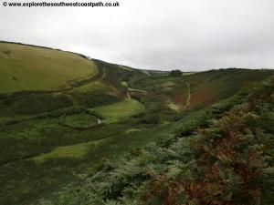
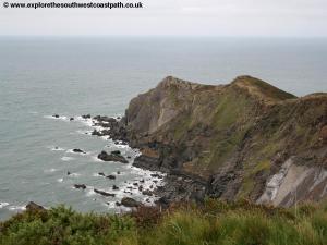
After passing the hut you once again face a descent back to sea level to cross another little stream (Tidna Shute) and the land around here is in the care of the National Trust. Climb back up the other side to Higher Sharpnose Point, a long headland which you can walk out along to get fine views of the surrounding coast. Keeping to the coast path keep heading south as the coast path undulates for a couple of miles, a welcome break from the numerous steep valleys. Looking south you have views of Greenway Beach another rock and pebble beach. The coast south from here is particularly spectacular with the sea crashing below.
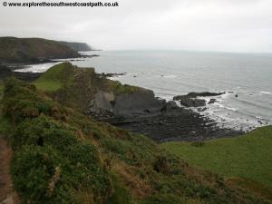
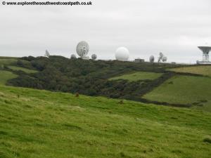
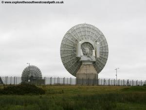
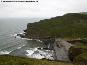
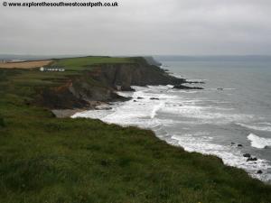
You soon come to another descent although this one is more gentle, down to Stanbury Mouth. The beach here is again pebble and rock, although there is some sand at low tide. You head briefly inland to cross the stream via a footbridge and then climb back onto the cliff tops towards a huge satellite tracking station where there are some truly huge satellite dishes, all safely behind tall fences. Here the coast path initially follows an access road/track (that can be muddy) beside the fence but then turns right to Lower Sharpnose Point where the path then rejoins the cliff top. Below is Wren beach another rocky beach. Beyond the path descends to Duckpool beach. Here there is a car park and the beach has a small amount of sand at low tide. Here you have to go inland to cross the stream that flows out onto the beach via a footbridge and then take the path that ascends back up the cliffs to the south to Warren Point. From here south, many of the beaches have sand at low tide.
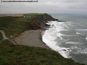
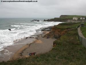
You have another descent back down to Warren Gutter and then another climb onto Stowe Cliffs. Keep to the cliff top path south until you come to Sandymouth where there is a National Trust car park and toilets. This is a popular beach with surfers and there is usually life guard cover in the summer. From here south the path is likely to be a little busier (you might pass some other people!) as we are now getting close to Bude. The path now undulates for around a mile to come to Northcott mouth, another very popular beach, particularly with surfers. Like many beaches in the area it is pebbles at high tide but has good sand at low tide, although bathing can be a bit hazardous with the large waves and strong currents.
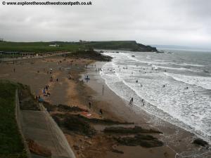
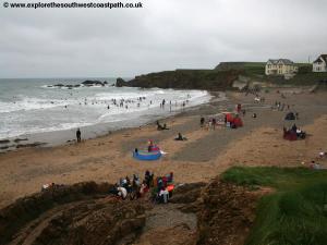
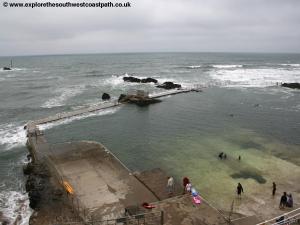
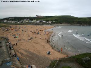
Climb back to the cliff top path and keep to the cliff top south until you reach Crooklets beach. This is a fine sand and shingle beach that is usually very popular. Round the little low headland past a tidal swimming pool to come to Summerleaze beach, usually the most popular in Bude. The town is a short distance inland from the beach here. The easiest way into the town is to walk to the back of the beach through the sand dunes to the car park and then keep along the road to come to Bude Strand at the south of the town. This is also where the buses leave from. If you've made the walk in one go then congratulations, as this is probably the toughest walk on the whole South West Coast Path with so many steep valleys and stream to negotiate and no significant towns or villages on the way.
From Bude bus service 319 runs twice daily back to Hartland, Monday - Saturday and on summer Sundays. However there is no public transport west of here, so to return to Hartland Quay (as I did), you'll need to walk around 2 and a half miles along the minor road through the village of Stoke and back to Hartland Quay. Except on Sundays, this bus also serves the village of Morwenstow, a short walk from the coast. In addition from Bude there are also buses to Holsworthy, Okehampton and Exeter.
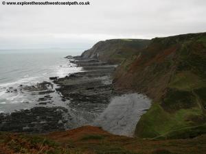
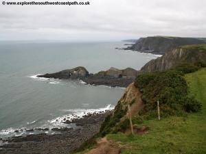
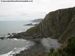
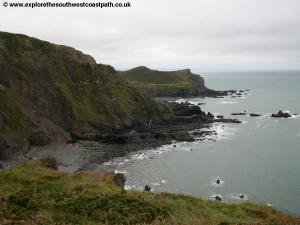
Here are some photos of the walk. Click each picture for a larger version and description.
 |
 |
 |
 |
 |
 |
 |
 |
 |
 |
 |
 |
 |
 |
 |
 |
 |
 |
 |
 |
 |
 |
 |
 |
 |
 |
 |
 |
 |
 |
 |
 |
 |
 |
 |
 |
 |
 |
 |
 |
 |
 |
 |
 |
 |
 |
Ordnance Survey Explorer map 126 covers this area of the coast path and is available from most book shops nationwide and many local shops, including at Clovelly and Hartland.
Streetmap is a web site which provides maps of the UK, including around Hartland and Clovelly. The links below will be of most use to the coast path from Hartland to Clovelly. These maps join to provide the complete coast path between the two points.