|
|

|
|
|
| Distance : 11 miles | Grading : ++ | OS Sheet : 194 |
![]()
Although not officially part of the South West Coast Path, there is a coastal path around Portland, and it is also mentioned in the official guide to the South West Coast Path, so it seems natural to include it. This walk starts from the well-known Portland Bill Lighthouse on the Isle of Portland and follows the Portland Coast Path round the east side of the island. From Portland there are stunning views over the bay towards Lulworth and you'll also pass working quarries extracting the famous Portland stone. The Portland coast path then joins the South West Coast Path at Ferry Bridge, the bridge linking the island with Weymouth. The path then goes through the suburbs of Weymouth, past Nothe Fort and over the bridge into Weymouth, where there is an excellent beach.
![]()
Portland Bill is the southern most point of the Isle of Portland. Portland is reached on the A354 from Dorchester. Once on Portland there are good signs to Portland Bill. There is a large car park at Portland Bill, just next to the lighthouse.
Portland has a very good bus service. There are regular buses (generally half-hourly in the summer, hourly in winter) from Weymouth to Portland Bill, as well as the towns and villages on Portland. Most buses are open-top in the summer. If there is a long wait for a bus to Portland Bill there are very regular buses (generally every 10 - 15 minutes) to Southwell, a short walk from Portland Bill. The buses depart from the Kings Statue on the sea-front in Weymouth, a short walk from the station, where there are regular trains from London, Winchester, Southampton, Bournemouth Dorchester and Poole and also trains from Yeovil, Westbury, Bath and Bristol. For more details on public transport to Portland Bill, see the links below.
There is a large range of accommodation in Weymouth and there is a good tourist information centre on the sea front that has details of local accommodation, and runs a booking service. The choice of accommodation on Portland is more limited, but the links below provide information on accommodation in the area.
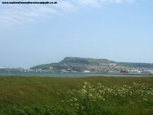
Portland is well known for it's stone and is the sight of many quarries, some of which are still active. The stone has been used in many buildings, but the most famous is St Paul's cathedral in London. Much of the island is now scarred with the remains of the quarrying work. The island is also well used by HM Prison service, with two prisons and a young offenders institution on the island. The island is also quite heavily used by the Military and Coastguard especially on the north of the island. There are also several fairly large towns on the island, so it has quite a diverse landscape.
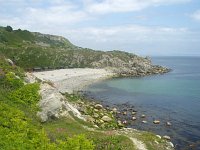
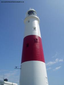
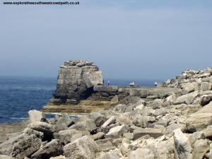
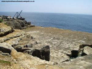
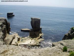
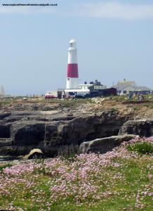
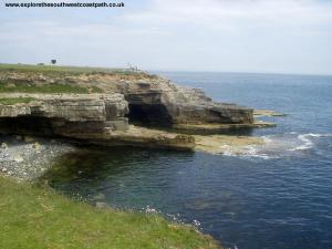
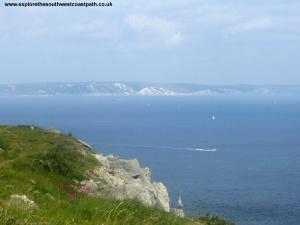
This walk starts at the famous Portland Bill lighthouse, at the southern most point of the Isle of Portland. The lighthouse is open to the public most days, except Saturday. There are superb views from the top. To the west of the light house is Pulpit Rock where you'll often see the sea splashing over the rocks. The coast path is signed on a stone in front of the lighthouse, so turn left as you face out to sea to begin. Ahead you can see rocks that clearly show the effect of quarrying and an old disused crane on the end of one part of the rock. Here the path initially runs along the flat cliffs, past the cafe on the left and round a small bay. Many of the small bays on this part of the coast show the scars of quarrying with large shelves cut into the cliffs. Soon you pass by a small site of beach huts on the left and in the sea to the right are the remains of some of the rocks that were not quarried, now left sticking out from the sea bed.
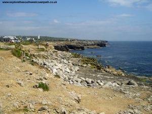
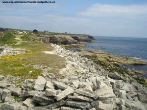
The cliff top now becomes quite grassy and you have good views back to the light house, still very visible at the end of the island. The coast path continues on the top of the cliffs round several small bays created by the quarrying though soon the path drops down into the edge of an old quarry where there are the remains of some buildings. Looking back you can see that the cliffs have now become gradually higher. In the distance to your right you can see the white chalk cliffs near to Lulworth. Round the edges of the old quarries you soon come to the small Freshwater Bay. Here the path heads inland, climbing up the cliffs to join the road for a short while. To the right is a disused quarry and further up, the area known as Southwell Landslip. As you walk along the road look out for the path off to the right again which drops down back onto the coast, leaving the road behind.
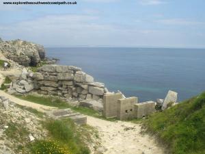
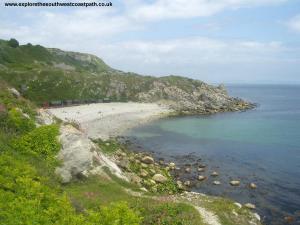
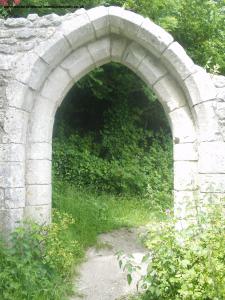
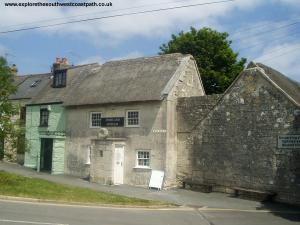
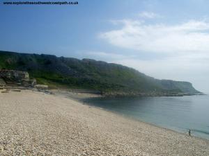
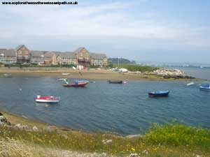
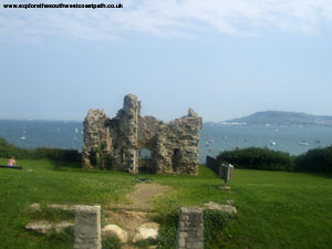
The path now goes along the bottom of the Southwell Landslip and soon you see the shingle beach of Church Ope Cove ahead, with some wooden beach huts behind. The path doesn't actually go down onto the beach (although there is a path down to the beach if you want to do so), but climbs steeply up onto the cliffs behind the beach. At the top there are the remains of Rufus Castle and also a ruined church, Old St Andrews Church. The castle (now privately owned) is thought to have been built between 1432 and 1460 as a coastal defence against the French. The church is believed to be Portland's earliest (partially) surviving building and was once the parish church of Portland until 1756 when it was partly dismantled. The remains were overgrown, but were cleared between 1978 and 1982 and you are now free to walk through them. The path briefly emerges onto the road near to Portland Museum, housed in a thatched cottage made of Portland stone.
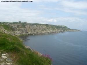
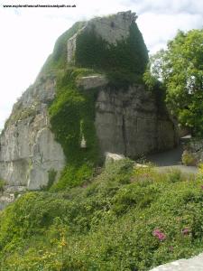
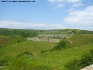
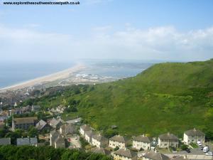
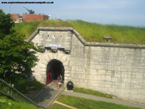
The path now continues on the cliff top with stunning views around the coast, although to the left is one of the large quarries on the island. The path continues next to the quarry before it comes to the high fences of the Young Offenders institution on the left and the path becomes a tarmack road. Follow this road round the institution, then it turns left towards another of the islands quarries, heading in-land for a while. Soon the path comes to the entrance to The Verne, another of the prisons on the island, which is partly built into the cliffs. Ahead there are stunning views of Chesil Beach, and this is one of the highest points on the island. The coast path rounds the prison, coming into Verne Common Road, where the path then descends through the residential streets of Fortuneswell, coming out to Portland Castle, now under the care of English Heritage and open to the public. From the castle you come out onto the main road (Castletown), which you follow as it becomes Castle Road. At the junction, turn to the right into Victory Road, then at Victory Square you have a choice of either following the road or walking along the shingle beach, leaving Portland behind. Looking back you can see how steep a drop it is from the top of the island to the coast, with the town of Fortuneswell climbing up towards the top of the island.
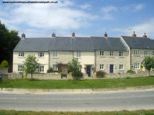
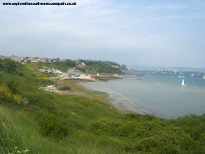
Once past the Royal Navy base on the right you can walk on the remains of the old railway line, which is easier going. Soon you'll pass a car park, toilet and small visitor centre on your left as you approach Ferry Bridge. Portland is only connected to the mainland by this single bridge and Chesil Beach. Cross the bridge and then, turn right when signed, onto the offical route of the South West Coast Path. The rest of the path into Weymouth is mostly on the edge of the residential areas, and for a time, along the residential streets. There are excellent views of Portland and the harbour for much of the walk though. There is a small park near Castle Cove where there are the remains of Sandsfoot Castle which is worth stopping to look at. Once past the Castle it is walking along residential streets all the way until you get to Nothe Point. It is fairly well signed though, so you shouldn't go wrong. Nothe Point is an attractive grassed area, with a fort at the end, which is open to the public. As you walk round the headland you get good views of Weymouth ahead. The path then descends from the headland to the harbour area at Weymouth.
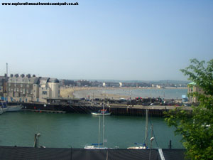
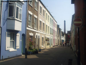
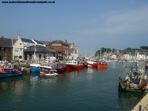
Once on the harbour side you can either follow the path round to the swing bridge or (if it's running), use the ferry across. The walk inland over the swing bridge is recommended though, as the harbour area is very attractive and there is always plenty to see. You might have to wait to cross the Swing Bridge over the harbour, as it seems to be lifted very regularly. Once across the bridge, you are on the edge of the shopping area of the town. You can either turn immediately right and down to walk along the harbour side until you come to the ferry terminal, or walk along the shopping street and then turn right after a short distance onto one of the roads that goes to the sea front.
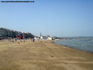
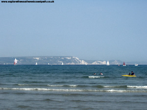
Weymouth has a very attractive sea front, with lots of traditional buildings and a clock tower part of the way along. The beach is excellent, with very fine sand and lots to do. It has a Seaside Award and so should be clean and safe and being east-facing is generally quite sheltered. You can see the white chalk cliffs around Lulworth ahead. The beach does gradually turns to shingle as you head further North though.
There are regular buses back from Weymouth to Portland Bill. Generally at least every hour in the winter and every half hour in the summer, with open top buses being frequntly used in the summer. All the buses go from the Kings Statue, near the South end of the beach. If there are no buses to Portland Bill, buses run regularly to Southwell, a little over a mile from Portland Bill. For more details of these bus services, see the links below.
Here are some photos of the walk. Click each picture for a larger version and description.
 |
 |
 |
 |
 |
 |
 |
 |
 |
 |
 |
 |
 |
 |
 |
 |
 |
 |
 |
 |
 |
 |
 |
 |
 |
 |
 |
 |
 |
 |
Ordnance Survey Landranger map 194 cover this area of the coast path and is available from most book shops nationwide. It is also stocked at the Weymouth Tourist Information Centre.
![]() Multimap is a web site which provides maps of the UK, including around around Portland and Weymouth. The links below will be of most use to the coast path from Portland Bill to Weymouth and the maps join to provide the complete coast path between these two points.
Multimap is a web site which provides maps of the UK, including around around Portland and Weymouth. The links below will be of most use to the coast path from Portland Bill to Weymouth and the maps join to provide the complete coast path between these two points.