|
|
 |
|
|
| < Plymouth to Cremyll | Noss Mayo to Mothecombe > |
| Distance : 14 miles | Grading : ++ | OS Sheet : 108 & OL20 |
![]()
From the maritime city of Plymouth this walk heads east along the waterfront crossing the river Plym that gives the city its name and passing an attractive creek to the pretty suburb of Turnchapel. Heading south from here the walk becomes more rural passing Jennycliff Bay and the sandy beach of Bovisand. Rounding Andurn point the coast becomes very rocky as we pass Heybrook Bay and the beautiful Wembury. From here we continue another mile or so east to Warren Point on the River Yealm. From here you can cross to Noss Mayo or Newton Ferrers by ferry or return to Wembury.
![]()
Plymouth is the largest city in Devon. From the M5 motorway continue on the A38 (Devon Expressway). This road crosses the south edge of Dartmoor and as you approach Plymouth take the A374 exit. There is a park and ride signed from here but if you prefer to continue to the city centre take the A374 south beside the River Plym. From here simply follow the signs for the city centre. There are numerous car parks in the city centre, a short walk from the coast path. There is also the Barbican car park that is virtually on the coast path just to the south east of the city centre. However it is strongly recommended to use one of the park and ride sites (these are well signed), rather than drive into the city centre as Plymouth does get congested. You may also choose to park in Wembury and take the bus into Plymouth, then walk back to your car.
If you are travelling by public transport then Plymouth has very extensive public transport links. There are trains on the main line to Exeter via Totnes and Newton Abbot and on to Taunton, Bristol, Birmingham, Reading and London (Paddington). Trains also go west to Penzance via Liskeard, St Austell and Truro. There is also a branch line to Calstock and Gunnislake from Plymouth. Trains to Plymouth are operated by Great Western Railway and Cross Country Trains. In addition there are also extensive bus services to most nearby towns and further afield to Torbay. Most bus services in Plymouth (other than local services within the city) are operated by First Devon and Cornwall.
![]()
As you would expect from the largest city on the South West Coast Path Plymouth has an extensive range of accommodation from small bed and breakfasts up to large hotels. Self catering accommodation is also available. The Visit Plymouth site has a comprehensive accommodation directory. Camping is available at Briar Hill Farm Briar Hill campsite in Newton Ferrers which can be reached by ferry during the summer from Warren Point, the end of this walk.
![]()
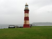
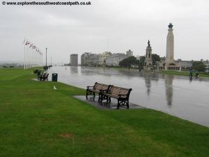
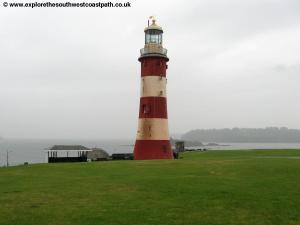
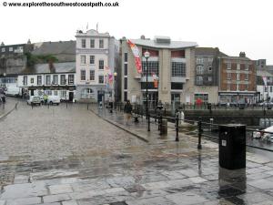
The city Plymouth is the only city that the South West Coast path passes through. The city has a rich maritime history and includes the famous Mayflower steps from where the Pilgrim Fathers sailed to America. The city houses the huge Devenport dockyard and also a commercial ferry port. Due to it's maritime importance the city was heavily bombed during the Second World War and much of the city was rebuilt in the 1960s. Recently areas of the city centre have begun to be re-developed, such as the new Drake Circus shopping centre. From the main shopping area of the city centre head south down hill to reach Plymouth Hoe. This is a lovely open grassy area with impressive views over the bay, known as Plymouth sound. Here you have the formerly Eddystone rocks lighthouse, known as Smeatons tower. The light house was moved here after a new replacement light house was constructed and is open to the public. Out in Plymouth Sound you can see Drakes island and the large breakwater beyond. To the right the river Tamar meets the sea and forms the border between Devon and Cornwall. To the east is the coast this walk will be following.
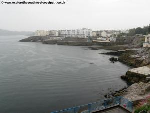
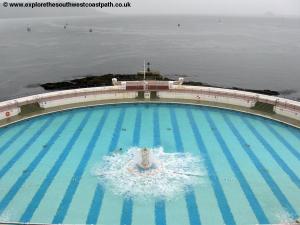
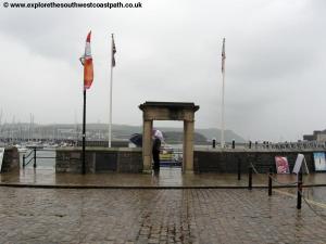
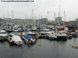
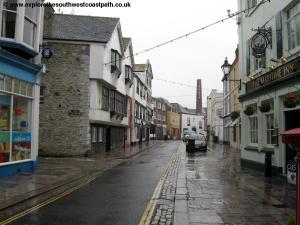
Head south from the Hoe and cross the road that runs alongside to the promenade beside the road. To the south is the Tinside pool, an outdoor swimming pool (lido). This pool was dereclit for many years but it has happily now been resorted and is open throughout the summer months. Turn left, keeping the sea to your right and follow the road past the rocky bays. Soon you come to the Citadel. This impressive fort was built in 1665 and is still in military use. As you reach the south east corner keep with the road and coast as they both turn to the north. You are now coming to another very historic part of Plymouth, the Barbican that retains many old buildings and it's narrow cobbled streets. The chimney of the Plymouth Gin distillery is a particular feature. It makes Plymouth Gin, a particular type of gin that by law can be made only in Plymouth. To the right you have a large marina with a large array of boats. On the right you pass the famous Mayflower steps from where the Pilgrim Fathers sailed to America (then known as The New World).
Take this jetty and cross over the footbridge to the National Marine Aquarium, a huge and impressive aquarium. Keep to the coast side of the aquarium and joins the curiously named Teats Hill Road. Here we leave the older Barbican area of Plymouth and head into the area known as Coxside. Keep to this road as it becomes named Clovelly Road. At the junction with Cattedown Road, take Cattedown Road to the right. This is still very much a working an industrial part of the city, but there is a pavement beside the road. Follow the road as it crosses a level crossing over the railway line and keep to this road as it turns left then right. Soon you rejoin the coast and have views over Turnchapel on the other side of Cattewater. Keep to the road is it turns east beside the coast and then passes through some more industrial areas. The coast path mark is marked by the acorn symbol painted on lamp posts in this area. Keep to the road as you cross the railway line once more and enter Maxwell Road which you follow to it's end at a large roundabout. You turn right here along Finnigan Road with the railway line to the right and keep to this road until you join the main A379 road at a T-junction, a dual carriageway at this point.
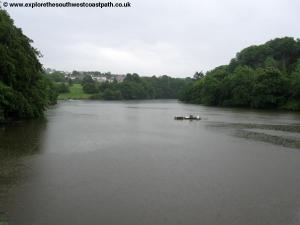
Turn right and take the pavement beside this very busy road as you cross the river Plym (after which the city is named) over Laira Bridge. Once over the river you keep to the pavement beside this road as it passes a little creek to the right. Plymouth has a very interesting water front and although parts of it, like this area, can be rather industrial the council has made a good job of trying to add interest to the path, there are lines from poems on the wall here and all sorts of objects painted with the coast path or coast path logo. At the large roundabout ahead at the end of the creek you turn right onto Pomphlett Road to another large roundabout. Here go straight on into Oreston Road, crossing Breakwater Road to your right and follow this road to enter the Oreston area of the city.
At the T-junction turn right and keep on Oreston Road, care needs to be taken on the path here as the road lacks a pavement for much of it's length and there are a few corners. To the right are some of the warehouses and docks whilst to the left it is a residential area. Turn right into Rolls Park Road when you come to the junction and follow this road to it's end. Here you come to a large green beside the River Plym from where you have fine views back to the city centre. Turn right here, keeping the river to your right. Follow the promenade beside the river and as it leaves the rivers edge follow it round. Do not turn right down Turnquay but instead keep straight on. Instead take the next right, Marine Road and then turn left onto Park Lane. At the end of the road continue up the track ahead and follow this footpath as it turns to the left, heading east past allotments on the right. Just before you come to the houses of Broad Park ahead follow the footpath to the right down to the waterside beside Hooe Lake to the left and Radford Lake to the right.
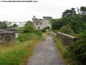
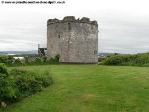
This is a natural interlude, and a particularly attractive one, in this otherwise urban part of the walk. Keep to the track along the side of Hooe Lake, a little creek leading off the Plym. To the left beyond the trees is the former Radford Quarry, now disused. Keep going on the track ahead is it becomes a causeway with Radford Lake to the left and Hooe Lake to the right. In the middle of the causeway is a sadly derelict little castle under which the path passes. Plymouth council is currently planning to sell this building to a trust to restore. The particularly attractive grounds here were once part of the ground of a large manor house.
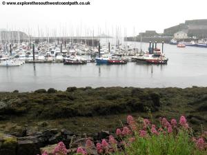
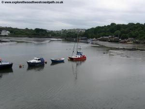
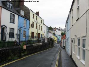
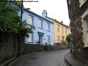
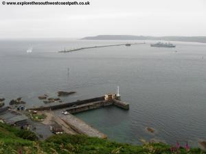
Once over the causeway the path turns to the right in front of the sewage works which makes for a less than pleasant smell in this area. Just as you reach a little jetty ahead the path turns left on a path briefly away from the coast and then follows this road as it turns to the right. Keep along this road until it joins a pleasant grassy area beside the edge of Hooe Lake to the right. At the end of this turn right along Barton Road still beside the lake to the right. You pass the remains of an old railway bridge to the right. Keep going along this road as you come to a boat yard on the right as the road turns to the left. Still following the road you pass Turnchapel Wharf on the right. Keep to the road as it becomes Boringdon Road. This area is very historic with it's very narrow road and brightly coloured buildings. When you come to a junction ahead turn left along St Johns Road. Take the path signed to the right a short distance beyond down to the water front and past some modern flats on the left. You join the small road, Shaw Road and follow this to a small roundabout with the rocky beach of Jennycliff Bay ahead. Here you have a choice of routes with a little circular walk taking in the headland of Mount Batten to the right. It is worth taking this little circular route as you climb up to the view point with the old tower. Ahead is the large breakwater breaking the waves to provide calmer waters in the harbour. You have fine views over Plymouth sound and back to the city centre and to the right is the citadel that the coast path earlier passed. Return on the path through the car park and back to the road and then head south on the path beside the rocky bay of Batten Bay, part of the larger Jennycliff Bay. This point marks where the walk becomes rural rather than urban.
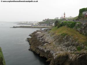
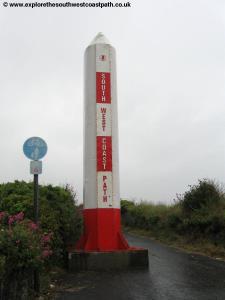
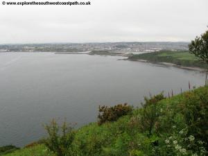
Take the path alongside the coast as it follows the edge of this rocky bay and then starts to slowly climb the cliff tops, passing a cafe on the left. Go through the gate at the top of this grassy area to leave the City of Plymouth where there is a marker post giving the distance to Poole and an amusing sign on the ground greeting walkers coming the other way into Plymouth with the comment 'Welcome to Plymouth, please wipe your feet'! The coast path ahead climbs up steadily along the edge of the cliffs. This is an area rich in military history and you can see the radar station on the cliff top and often see the various naval ships lined up behind the breakwater to the right. Just under the radar station the path divides and there is no sign, keep to the most coastal route off to the right. Keep to the coast path as you had south enjoying the fine views from these high cliffs and take in the views of Plymouth sound for the last time on this walk.
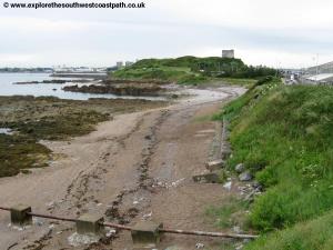
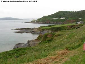
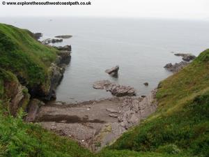
Soon below you have Bovisand Fort once a military fort but now used by a diving school. The path turns left here heading east following the cliff top and then coming round to the car park above Bovisand beach. This is a fine sandy beach that is also quite rocky in places. It is very popular in fine weather with many locals from Plymouth coming here to enjoy this excellent beach. You descend down and follow the path beside the back of the beach. Once rounding the beach you take the track beyond that comes a minor road leading into the adjacent Bovisand Park Estate a holiday and residential park. You follow the main road through this estate. The road broadly follows the coast first south and then briefly west as you pass the last of the houses. The road ends at the cliff top where the coast path continues to the south. The path now gently past Andurn point and into Westlake Bay. These rocky bays are quite impressive with the rocks jutting a long way out to sea and the little island of Shag Stone visible beyond.
The path rounds the corner heading east to come to a minor road leading into the little village of Heybrook Bay. The beach here is mostly rocky and the little Hey Brook that gives the village it's name flows over the beach. Take the path beside the tennis courts of the houses and follow it a short distance inland to the road where you turn right crossing the little brook and turn right again into Marine Drive forking off to the right onto the coast path again.
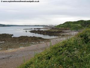
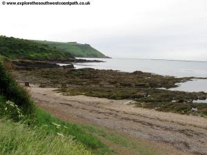
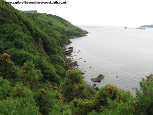
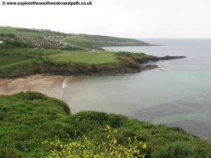
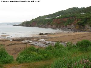
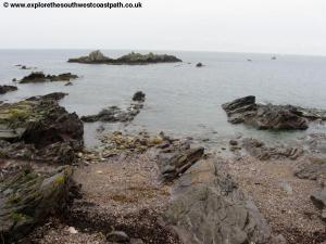
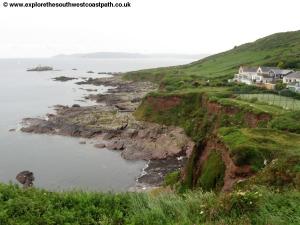
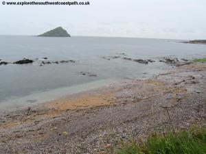
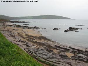
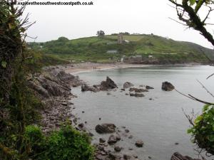
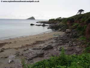
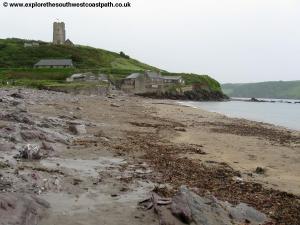
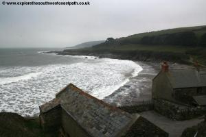
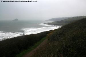
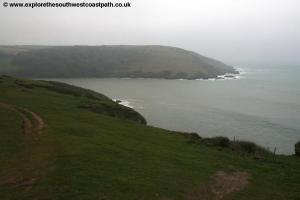
The path now heads east on top of the low rocky cliffs around Wembury Point, now in the care of the National Trust. The beaches here are a mixture of rock and sand and are especially beautiful. Half a mile off shore to the south can be seen The Great Mew Stone, a large rock now a nature reserve. Keep along this low cliff top path around these various little rocky bays until you reach the lovely village of Wembury. This is a particular attractive village with the old mill, toilets and cafe just at the back of the beach and the church above.
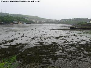
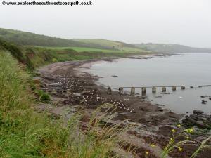
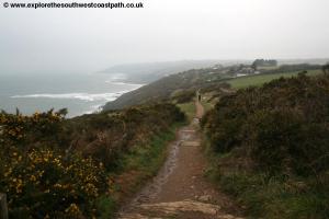
The beach here is small but sandy and very secluded and is popular in the summer months. Behind the beach are toilets and a cafe as well the Marine centre that is also open to the public. To continue the walk, take the path up behind the main beach car park and below the church. Soon a path winding up from the end of the car park joins this path from the right. Continue past a house on the right and another couple on the left, crossing the track leading to the house on the right. Continue past the last of the houses on the left. Keep to the main path past a couple of fields on the right and soon the path becomes narrower and grassy as you continue south east along the area marked as High Cliffs on the map. Horses are often grazing on the path here. The path then soon turns a little to the left, briefly heading north east to descend down and back up the little valley south of New Barton, although this is not a steep or deep valley. Continue back along the obvious coast path and heading south east once more until you reach a cottage ahead. Here turn right, taking the right most of the two paths and follow this as it descends down to a slipway by Warren Cottages at Warren Point.
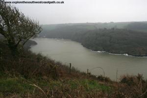
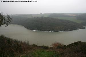
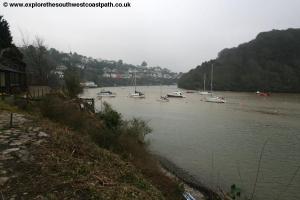
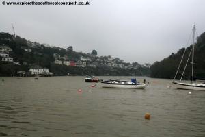
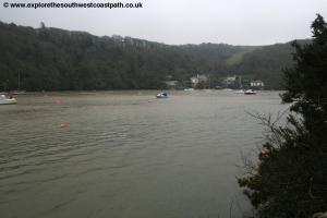
Ahead is the river Yealm and the coast path crosses here via a ferry, although this walk ends here at Warren Point. To get back to Plymouth, depending on the time of year you can either cross via the ferry to end the walk in Noss Mayo or if the ferry is not running you will need to return by bus from Wembury, which means you have to re-trace your steps from here back to Wembury. The ferry runs between 10am and 4pm from late March or early April to the end of September. During bad weather the ferry only runs between 10am and 12pm and 3pm and 4pm. The crossing currently costs £2.50. The ferry will take you to either Newton Ferrers or Noss Mayo (ask the ferrymen where you want to go). To get the bus back to Plymouth it is easiest to cross to Newton Ferrers. On reaching the quay turn right and after around 200 metres you will reach the Yealm Hotel. From here Tally Ho Coaches bus service 94 runs 6 times a day back to Plymouth. Or if you cross to Noss Mayo, follow the road for a little over half a mile to reach Noss Creek. Follow the road round and at the top of the creek into Noss Mayo and continue ahead uphill to the car park and tennis courts, the same bus runs from here to Plymouth.
This is a long walk but there are several places you could split the walk or cut it short. The urban area of Plymouth I s well served by buses. From Mount Batten Point there is a regular ferry service back to Plymouth (stopping near the Mayflower steps). This runs every 30 minutes seven days a week, on the hour and half hour all year round. Operating times vary by season and day of the week but are always at least 9am to 6pm. During the summer the service normally operates to 10:30pm or 11:00pm and on weekdays starts earlier than 9am. Bovisand is served by a bus service during the peak summer months only, Plymouth City Bus route 54. This generally runs an hourly service back to Plymouth. Plymouth City Bus service 49 runs 3 times a day Monday – Saturday from Heybrook Bay back to Plymouth. Finally from Wembury, First Devon and Cornwall service 48 runs 8 buses a day from Wembury back to Plymouth, starting from Southland Park Road roughly 500 metres inland up the road from the coast path.
![]()
As mentioned above to get back to Plymouth from Warren Point you either need to take the ferry over to Noss Mayo or Newton Ferrers which only runs during the summer months (generally early April to late September). It is recommended to take the ferry to Newton Ferrers if possible because this is the shortest walk to the bus stop. Once over, take Tally Ho Coaches bus service 94 back to Plymouth which runs roughly 6 times a day Monday to Saturday only (so be aware you may have to wait a while and it doesn't run on Sundays). Or if you prefer (or during the winter when the ferry doesn't run) walk back to Wembury and then take First Devon and Cornwall bus 48 which runs roughly 8 times a day seven days a week. This runs from Southland Park Road roughly 500 metres up the road from the beach at Wembury.
![]()
 |
 |
 |
 |
 |
 |
 |
 |
 |
 |
 |
 |
 |
 |
 |
 |
 |
 |
 |
 |
 |
 |
 |
 |
 |
 |
 |
 |
 |
 |
 |
 |
 |
 |
 |
 |
 |
 |
 |
 |
 |
 |
 |
 |
 |
|
![]()
Ordnance Survey Explorer Map 108 covers this area of the coast path and is available from most book shops nationwide and various book shops in Plymouth.
The links below cover the coast path between Plymouth and Wembury. The coast path is marked with green coloured diamonds on the map.
![]()