|
|
 |
|
|
| Distance : 11 miles | Grading : +++ | OS Sheet : 102 |
![]()
This is a wonderful walk beginning in Penzance and heading through neighbouring Newlyn along roads. From Newlyn we soon reach beautiful Mousehole, a classic Cornish fishing village. From here the coast becomes a bit more wild as it passes Lamorna Cove and the lighthouse just to its west. The walk continues via St Loy’s Cove and Penberth and ends at wonderful Porthcurno with its magnificent sandy beach and the Minack Theatre perched on the cliffs overlooking the beach.
![]()
Penzance is easily reached from the main A30 trunk road through Cornwall. Enter Penzance on the A30, passing the Heliport and Tesco and at the roundabout beyond turn left along the road into Penzance with the wall beside the railway line on your left hand side. As you reach the station on your left go left with the road after the traffic lights around the little one way system beside the station. As the road widens to two lanes, keep in the left hand lane (signed for parking). Keep on this road soon passing the Wharfside shopping centre on the right. Just past this, turn left when signed into the main car park.
If you are coming by public transport, Penzance has good transport links. There is a broadly hourly train service from Plymouth via Liskeard, Bodmin Parkway, St Austell and Truro. Most trains on this route also run through from Exeter and from there go to either the Midlands or London. There are also regular bus services from St Ives, Hayle, St Just, Helston, Porthleven and Falmouth and the bus station is adjacent to the railway station.
![]()
Penzance, being a good sized town has a large range of accommodation. There are large hotels down to small guest houses. There are also self catering and caravan and camping accommodation located close by, especially further east near Marazion. Sadly the tourist information centre in Penzance has closed however the Visit Cornwall website provides a good directory of accommodation of all types in Penzance. The following links may also be of interest.
![]()
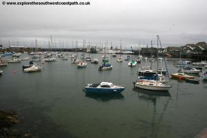
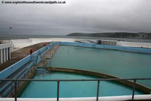
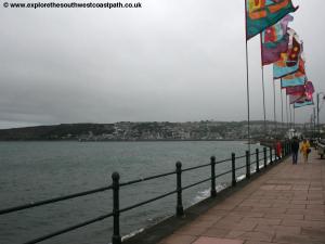
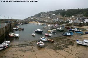
The walk begins from the main car park on Penzance sea front (which adjoins the bus and railway stations). From the car park walk along Wharf road beside the Wharfside shopping centre. Soon you have the pretty harbour on your left. The road becomes a causeway with water on both sides and you soon cross a lifting section leading to an inner harbour on the right. Soon on the left you pass the entrance to the dock. During the summer months the Scillonian III sails daily from here to St Marys on the Isles of Scilly. Continue on the main road soon coming to the little square at the Dolphin Tavern. Follow the road round and it soon opens up with the beautifully restored Jubilee Pool on the left (an outdoor swimming pool).
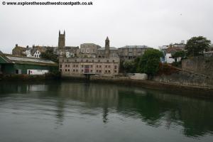
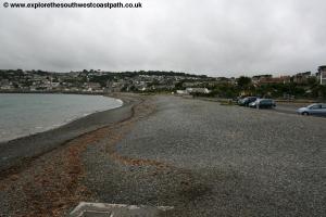
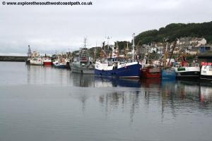
Continue past the pool onto the main promenade, where there are some coloureful flags flying and you can see round to Newlyn Harbour ahead. Indeed it’s difficult to tell where Penzance ends and Newlyn starts. As you continue on the promenade there is soon a pebble beach to your left. Continue on the promenade passing a car park on the right. Here continue on the promenade as you no longer run adjacent to the road on the right, which is instead replaced by some pleasant gardens. Continue beside the shingle beach to the little car park at the end by the Tolcarne Inn. Follow the minor road here, passing the garage on the left and then crossing over the stream. Ahead you come to the little village square with the memorial and here keep to the right of the two roads, The Strand, as the first leads just out onto the harbour wall of Newlyn Harbour. Continue along the Strand with the fish market on the left and shops on the right hand side. Penzance Harbour is largely connected with leisure and the commercial service to the Isles of Scilly whilst Newlyn is very much the fishing harbour. Continue on the main road beside the harbour as it soon begins to climb up the right hand side of the harbour, past a building with lights saying “Save our Fishâ€.
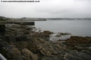
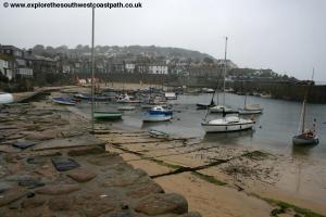
Ignore the turnings off to the right and keep to the road beside the harbour, Fore Street. Soon you pass the southern pier of the harbour, South Pier, on the right which marks the end of Newlyn Harbour. As the road turns, you have a little parking area on the left and just beyond this take the narrow track off to the left. This follows on a concrete path just below the main road. On the right of the road is a large quarry and the disused concrete structures on the beach and path below the road were presumably connected with this. This concrete path soon re-joins the road. You follow the road for around 100 metres and just before the cottages on the left you take the path off to the left (near the bin), just before a parking lay-by on the road ahead (it is easy to miss). This descends down to another concrete path just below the beach which you now follow all the way to Mousehole. If you miss this, you can just continue on the road which runs parallel and also has a pavement. Soon you pass the old Lifeboat station at Penlee Point which has been disused since 1983. Continue on the low concrete path passing beside the main car park and soon a smaller car park just before the harbour. Continue on the road past the harbour.
This is a very pretty spot, reminiscent of so many Cornish fishing villages, with the small boats tied up in the harbour, backed by a sandy beach, offering protection from the sea on this exposed coast. Continue on the road along the back of the harbour soon passing the memorial at the end of the harbour slipway. Care is needed along this stretch as although not an especially busy road it has no pavement.
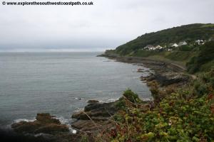
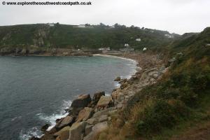
As you round the harbour there is soon a house on the left, so you continue on the road between the houses, briefly losing the view of the harbour. As the road forks round to the right and comes to a junction take the road off to the left. This is signed as a dead end for road traffic but is also signed for the coast path. Follow this road to the south end of the harbour where there is another car park. Here turn right away from the coast along Portland Place. Ignore Gurnick Street to the left and keep going to the main road, Chapel Street. Here turn left and at the junction with St Clements Terrace ahead, keep with the main road going up hill. Continue up this hill passing the last of the houses of Mousehole where the road then has hedges on both sides. Soon you pass a few more houses ahead. As the road turns to the right and you have a narrower road off to the left (signed as a dead end), take this and after a few metres you pass a coast path sign on the left. This passes a large house and then narrows to a track with hedges on either side. Keep to this track as it twists and turns between fields and then heads out into open land on the cliff top. The path then drops down to the base of the hills along the coast, so you’re now walking just above the sea and rocks. Keep to this low-level path passing a few trees ahead.
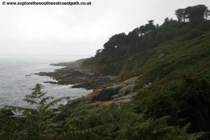
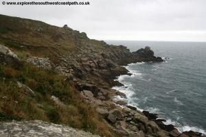
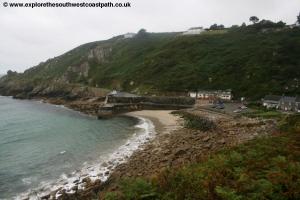
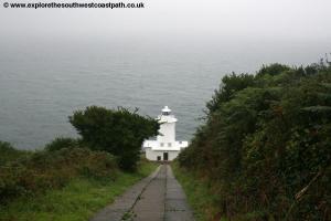
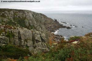
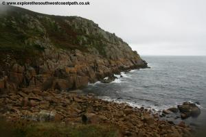
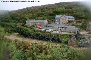
As you approach Carn-du and Kemyel Cliff ahead, the coast has many rocky outcrops that are typical of the coast in the far west of Cornwall. At the end of the cliff you have to take the narrow path around some of these rocks. Once around your rewarded with fine views of Lamorna Cove ahead. This is a sheltered little cover, with a rocky beach and a small quay at its south end. Pass the car park, slipway and the quay and continue on the low level path beyond the quay. Keep to the low-level path to Carn Barges where the path turns a little away from the coast, but keep to the most coastal of the footpaths. Soon you come to some little fields ahead where the path turns a little to the left and runs beside the south edge, soon passing the steep road leading to the lighthouse. Continue on the track past the Lighthouse and past a few houses on the right where you then head through bushes and along the heather and gorse-covered cliff top to Boscawen Point.
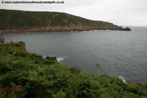
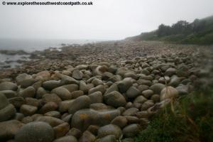
Turn right with the path and coast here and follow as the coast path soon descends down to sea level again. Here you come to the rocky and pebbly beach at St Loy’s Cove. The path goes right along the back of the beach here and then after passing a house on the right, turns right a little away from the beach and soon joins a track, where you turn left, passing another house. Keep on this track as ahead it soon turns to the right. There is a minor path off to the left here, do not take this but keep to the main track as it curves to the right and then comes to a T-junction where you turn left. Follow this along the now very rugged coast to the rocky beach at Porthguarnon.
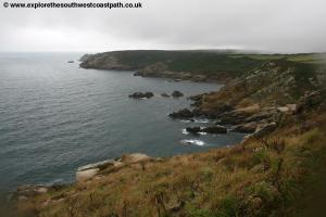
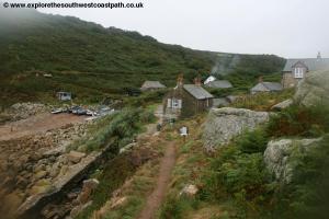
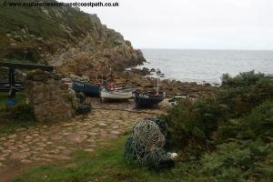
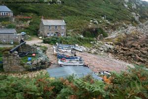
Here the path zig-zags down to the level of this rocky beach and back up the other side. Keep to this path along the cliff top ahead, enjoying the fine views back along the coast. When this comes to another T-junction of tracks turn left back towards the coast. Ignore the second path off to the right and keep on the main path out to the tip of the headland. Take the path that descends down from here to Penberth Cove. Here you’ll find another rocky but sheltered little cove and there are toilets at the back of the beach here. The cove has a few attractive cottages and many boats, as there is still some fishing carried out from here.
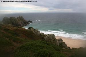
Walk through the car park and the little boat park area (with the fishing nets and lobster pots) and beyond that take the main path up onto the cliff tops. This zig-zags as it climbs out of the cove soon offering fine views back over this picturesque little village. The path rounds Cribba head and passes another little rocky beach below. Soon beyond this you come to another headland. A path goes off to the left here, but the main coast path ignores this and continues ahead. From the path going to the left you can reach Logan Rock. This is a rocking stone and the path that leads out to the headland does descend and offers (difficult) access to the beach below at low tide.
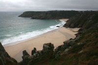
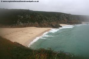
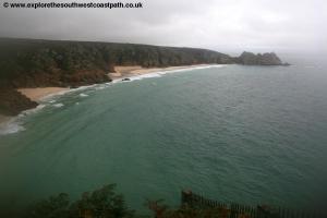
Keep to the main coast path and if the tide is low you’ll now be walking above an absolutely gorgeous beach, with white sand, turquoise sea and lovely shallow and sheltered sea. It’s a really perfect beach and worth the difficult access needed to get to it (if the tide is low). The path ahead comes to a junction with a wide track off to the right. This leads to Treen and the campsite. Ahead the coast path takes the wide track ahead, but there is another (more scenic) path that follows west along the cliff tops. This is recommended and the paths soon join in any case. Now keep to the main path ahead that soon descends down to the lovely beach at Porthcurno.
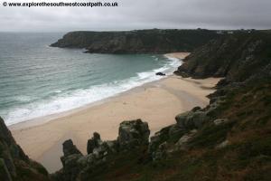
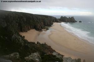
This is one of the best places in Cornwall, a truly magical location with a lovely sheltered beach with white coarse sand backed by dunes (a rarity in West Cornwall). This really is a breath-taking location at which to end the walk. On the cliffs to the west of the beach is the Minack Theatre, an open-air theatre which offers the chance to take in a play in a magical location, listening to the sound of the waves below. This can be accessed by the steps up the cliff at the far end of the beach. When a performance is not taking place it is usually possible to visit the theatre. Porthcurno is also famous as the site for the first trans-Atlantic telephone cables which were laid here, and the Telegraph museum further up in the village tells the story of how Porthcurno was once an important centre of communication. To end the walk, take the main path up from the back of the beach which brings you out into the car park. Walk through the main car park and the bus stop where the walk ends is at the far end, between the main car park and the car park for the telegraph museum.
![]()
To get back to Penzance there are several bus routes and the ease of the journey rather depends on the time of year. Western Greyhound service 501 runs between Penzance and Lands End, and journies towards Lands End server Porthcurno however at the time of writing only one journey in the other direction serves Porthcurno. Therefore it is best to take this bus to Lands End and remain onboard for the return journey. This bus runs 4 times a day at the time of writing. Western Greyhound also operate service 504 which also runs Monday – Saturday. This runs between Penzance and St Just via Lands End. This serves Porthcurno twice per day towards St Just and during the summer twice per day in the other direction (with the last part of the journey to Penzance operating only on request to the driver when you get on). In winter the last part of the journey is request from Lands End, which means the bus goes to Porthcurno only if requested by someone already on the bus when it leaves Lands End. First Devon and Cornwall service 1A runs 4 times a day between Penzance and Lands End via Porthcurno and unlike the other bus routes also runs on a Sunday (but only 2 or 3 times to Porthcurno). Finally and during the summer months only, bus 300 is an open-top bus service running roughly once every two hours on a route from Penzance to St Ives via Porthcurno, Lands End and St Just. Note that buses on this route serve Porthcurno only during the peak season, outside of this time the buses omit Porthcurno. Due to the variety (and often infrequent) routes it is best to check the timetable before you leave. If you are driving you may also prefer to park at Porthcurno in the morning, take the bus to Penzance and walk back to your car so that you then don’t need to worry about the return bus times.
![]()
Here are some photos of the walk. Click each picture for a larger version and description. Due to the rain my camera lens steamed up later on the walk which has caused some blurring (it is not a Photoshop effect!).
 |
 |
 |
 |
 |
 |
 |
 |
 |
 |
 |
 |
 |
 |
 |
 |
 |
 |
 |
 |
 |
 |
 |
 |
 |
 |
 |
 |
 |
|
![]()
![]()