 |
|
|
| Distance : 11 miles | Grading : ++++ | OS Sheet : 102 |
This walk in the Penwith area, in the very far west of Cornwall, begins from Zennor and heads along the rocky cliffs, passing some rocky and sandy beaches on the way. Soon you reach the beautiful Portheras Cove with it's beautiful white sand and continues west to Pendeen Watch with it's lighthouse. Heading west from here the walk passes some of Cornwall's extensive mining heritage passing the mines and engine houses at Geevor, Levant and Botallack. The walk ends at Cape Cornwall although to return to Zennor you will need to walk a mile or so inland to the town of St Just.
Zennor is around 6 miles west of St. Ives in North Cornwall. From the A30 heading towards Penzance after passing Hayle you come to a large roundabout turn right here on the A3074 signed for St. Ives. You pass through Lelant, Carbis Bay and then arrive in St Ives. Note that the roads are very narrow in St Ives and so the traffic can be very heavy and slow moving, especially in the summer. Just before you reach the harbour you turn left on the B3306 signed for Zennor and follow this for the next 5 miles or so, as it twists and turns. When you have Zennor signed to the right take this road and by the church follow the road as it turns sharply to the left. There is a small car park on the right (where the toilets are signed).
If you prefer, due to the infrequent buses you might instead prefer to park at Cape Cornwall and take the bus to Zennor and walk back to you car. If you do this there is a car park at Cape Cornwall which is pay on entry (National Trust members free). From there it is a little over a mile inland to St Just from where the buses depart. See the directions to St Just at the end of the walk.
If you are travelling by public transport bus service 508 (operated by Western Greyhound) runs roughly once every two hours on a route from St Ives to Zennor to Penzance and vice-versa. During the summer months there is also a coastal service (route 300) that runs between Penzance, Lands End, St Just, Zennor and St Ives. For details on these service, please see the links below.
Due to it's remote location, accommodation in and around Zennor is limited. The Tinners Arms, the only pub in the village, offers bed and breakfast in an adjacent building. Tregeraint Houses also offers bed and breakfast in Zennor. There is also an independent hostel, Zennor Backpackers that offers beds in shared dormitory's. There is a wider range of accommodation available in and around St. Ives and St. Just.
From the car park in Zennor, turn left and return to the pub and continue on the road ahead passing the church on the right. Just past the church turn left along the track signed as going to the coast path. Follow this past a farm and a couple of houses on the right. Soon the path has rocks and gorse around it as you approach the coast . Shortly after passing a large house on the left where the path narrows to a track ahead turn left at the stone sign to pick up the coast path.
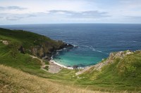
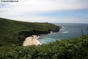
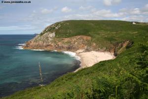
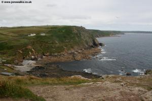
The path heads steeply down hill to a little rocky stream which you cross via a footbridge. To the right here is Pendour Cove although access to the beach is difficult and not recommended. Instead take the path that climbs back up away from the valley and onto the cliff top. You keep to the obvious cliff path with the dry stone wall on your left and soon turning right to head out with the path to the headland of Carnelloe with a single house at the end. Rounding this headland you descend to another valley to Porthglaze Cove where you cross the stream via another footbridge. The beach itself is not accessible and is mostly rocky. Climbing up the other side keep to the well signed coast path to round Boswednack Cliff. Once round the cliff you continue to Lean Point, with a sand and rocky beach to the right. Here you cross the access road to what looks to be a lovely house right at the end of Lean Point. Continue on the path with the coast to the right. There is access down to Treen Cove to the right a really beautiful beach with white sand and turquoise sea although the access is steep and quite difficult.
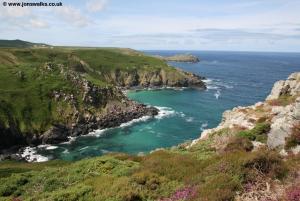
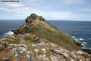
As you approach Gurnards Head on the right you pass the ruins of Chapel Jane. The official route of the coast path cuts off Gurnards Head although there is a path out to the end of the headland if you would like to explore it further. To keep to the official route keep the dry stone wall on your left soon rounding a corner, keeping the field boundary on your left. Ahead when you come to the stone wall, cross this and continue on the left hand side of the field. About half way along the left edge of the field the path goes diagonally across the field, crossing the western edge of the field about midway along and soon rounding Porthmeor Point. Rounding this headland you soon come to Porthmeor Cove a lovely rocky beach with beautiful white sand at low tide. There is access down to the beach if you feel want to visit it.
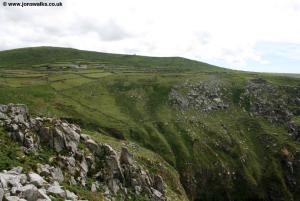
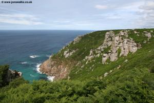
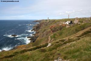
Keeping to the coast path you have to head a little inland to cross the valley and little stream that flow to the beach. Once up the other side the coast path hugs the coast and keeps outside of the numerous dry stone walls on the left although the path is rocky in places. You pass the rocky inlets of Great Zawn and Halldrine Cove and care is needed here as there is a steep drop off to the right. Continue past Bosigran Head which the path does go most of the way out onto and soon to Porthmoina Cove another rocky beach. From here for most of the rest of the walk you are never far from the extensive remains of Cornwall's once thriving mining industry. There were many mines along the coast here (and many more inland), mostly tin mines and now mostly derelict although further west we pass a couple that have been restored.
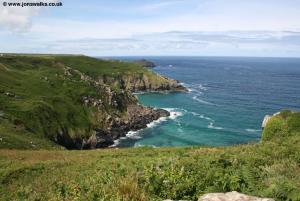
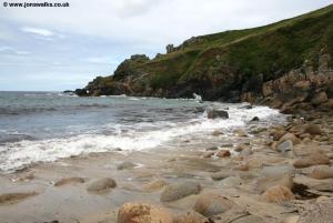
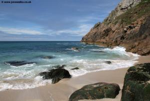
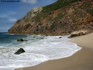
Continue on the obvious coast path along the cliff top here soon with the road close by on the left. During the summer there are buses along this road if you wish to cut the walk short. To continue on the coast path simply keep to the cliff top path and soon the coast ahead becomes a little less rocky, with the jagged rocks giving way to a covering of bracken and heather. The path here generally keeps to the cliff top and on the coastal side of any fields and is easy to follow. In a little over a mile you come to the beautiful sandy beach of Portheras Cove another stunning beach with white sand and beautiful turquoise sea. Note that there are warning signs here about sharp fragments of a ship that ran aground here buried under the beach but I understand these have now been cleared up and I didn't notice any problems. If you can spare the time it is well worth stopping here for a rest and to enjoy the stunning beach.
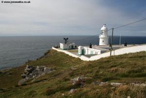
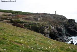
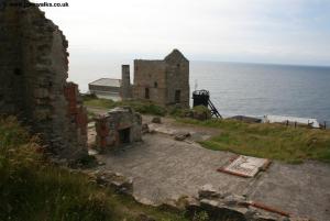
Take the path up from the beach and continue on the wide path through the bracken, soon joining the track leading to the lighthouse of Pendeen Watch, built in 1900. Keep to the landward side of the lighthouse and once past it, follow the access road heading south. Pass a large house on the right and level with the end of this house turn right off the road and onto another footpath through the bracken that lines the cliffs. The coast path is initially at a lower level but soon climbs up to the tops of the cliffs once more and soon coming to the vast remains of an old mine. You can see the large numbers of ruined buildings and old towers dotted all over the cliffs and the old slag heaps making this a rather industrial looking landscape. This is Geevor Mine which is now a tourist attraction and open to the public.
The official route of the coast path goes along the track behind most of the buildings, but there is another track a little lower down which you may prefer to follow, both are permitted routes and soon join. Just after you pass Geevor Mine you come to another at Levant Mine and the associated beam engine. Unlike Geevor, this one has been restored and is now owned by the National Trust and is open to the public to visit (although not every day, so check the website. Pass through the car park of Levant, keeping to the more coastal of the two tracks to continue on the track ahead. Note that this is a byway so use by vehicles is also permitted. This track soon climbs, offering fine views back to Levant and soon becomes more rural again. After passing Stamps an Jowl Zawn there is a permissive path a little closer to the coast although the official route of the coast path continues along the byway a little further back from the cliff edge.
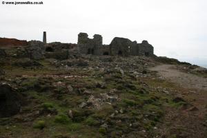
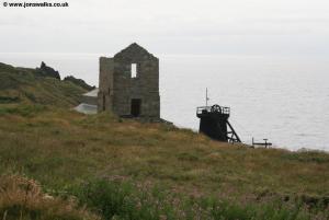
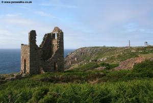
Soon you approach another old mine, Botallack and just before you come to the main buildings turn right off this track and along a path along the coastal side of the mine. Beyond the main mine buildings the path soon becomes a track again approaching a few more ruined buildings. Soon a path turns off the right along the cliff top and away from the main track, as it turns to head inland so take this path off to the right passing through heather and gorse. Soon you reach the ruins of some old buildings at the end of the headland. Rounding this little headland you end up doubling back on the other side. When a slightly smaller path forks off to the right heading downhill to the valley, take it as it heads down to join another track along the bottom of the valley. On reaching this turn left away from the coast and shortly afterwards right on a path that climbs steeply and diagonally up the hill ahead and on reaching the top you turn right keeping along the cliff top path around a golf course. The path goes the coastal side of the tees and greens and soon joins a road a wide track where you turn right and follow this round to the public road where you turn right and head down the road to the main car park at Cape Cornwall, where the walk ends.
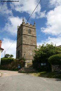
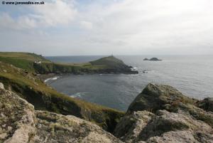
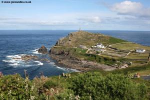
Cape Cornwall is a beautiful headland and although not the most westerly (that being Lands End a few miles south) it feels perhaps spiritually at least the west end of Cornwall being thankfully devoid of the tacky tourist attraction at Lands End. The headland was kindly purchased by Heinz and donated to the National Trust who now care for it. If you are returning to Zennor by bus head inland on this road soon passing the golf club. Keep ahead here and you come to Boswedden House where there is a Bed and Breakfast. The road twists and turns a bit here but keep to the road ignoring the footpath soon signed off to the right along a farm track. Soon you come to the first houses of St Just. Ignore Cam Gloose Road that joins from the right and keep ahead. Continue along this road passing the school on the left and coming to Market Square ahead. Turn right here passing the clock tower on your right to the second square and turn right here down Market Street. Soon you come to the main car park and the bus station is at the near end of this car park. From here there are buses to Penzance and less often, back to Zennor village.
To return to Zennor follow the directions above to St Just. From St Just during the summer months bus service 300 runs direct back to Zennor. Otherwise Western Greyhound service 507 runs 4 times a day (be sure to check the time of the last bus) to Gurnards Head Hotel from where there is a connection bus, number 508 on to Zennor. Through tickets can be issued. I used this service and found the company to be excellent, with the driver of the first bus (the 507) using the radio to talk to the driver of the connecting 508 bus to ensure he was on time and to tell him that I was waiting - a very professional service. Due to the remote nature of this area the bus service is sparse so be sure to check the timetable before you leave and if you are driving, consider the option of parking at Cape Cornwall and taking the bus to Zennor in the morning, having first checked when it departs so you can arrive in time. This means you can walk back to your car and relax as you do not need to worry about missing the last bus or having a long wait for a bus.
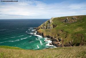
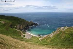
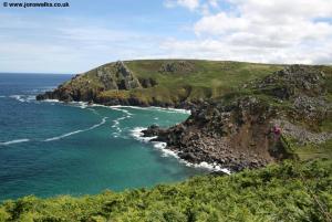
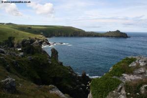
Here are some photos of the walk. Click each picture for a larger version and description.
 |
 |
 |
 |
 |
 |
 |
 |
 |
 |
 |
 |
 |
 |
 |
 |
 |
 |
 |
 |
 |
 |
 |
 |
 |
Ordnance Survey Explorer map 102 (Lands End, Penzance and St Ives) covers this area of the coast path and is available from most book shops nationwide and many local shops.
Streetmap is a web site which provides maps of the UK, including the area between Zennor and Cape Cornwall. The links below cover the coast between Zennor and Lelant.