The coast of Somerset offers tremendous variety. Much of the coast of North Somerset is on the Somerset Levels and hence flat, but mixed in with some large hills and headlands, such as Brean Down and Middle Hope that extend from the Quantock Hills. It is dominated by numerous rivers and drainage channels. Heading further south the coast soon becomes far more rugged as it crosses first the Quantock Hills and then the hills of Exmoor, one of Britain's most beautiful and least visited National Parks.
 |
 |
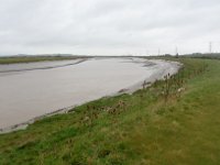
| This walk follows the coast and banks of the Severn as much as possible from the Severn View services on the M48 at Aust south to the River Avon. Most of the walk offers beautiful views over the Severn, although a few miles part of the walk are through an industrial area, which is less pleasant. Near the end of the walk, we cross the M5 motorway and the River Avon to finish in the village of Pill. |
|
 |
 |
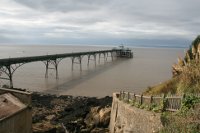
| This walk is a walk of two parts, the first part heading from the banks of the Avon around the back of the large Royal Portbury Dock (where public access is not permitted) following roads and paths adjacent to the industry. The walk soon reaches the coastal town of Portishead and the banks of the Severn, where the second part of the walk follows the banks of the Severn heding south west to end at Redcliff Bay, on the edge of the town. |
|
 |
 |
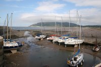
| This walk follows (as far as possible) the coast from Worle to Portishead. As there is no footpath along the coast from Worle and Sand Bay the first few miles of the walk are along roads via the villages of Hewish and Kingston Seymour but soon reaching the coast just south of Clevedon, offering fine views back to Sand Bay and to the coast of Wales on the other side of the Severn Estuary. From Clevedon to Portishead there is a good coast path along the cliff tops that we follow for the rest of the walk. |
|
 |
 |
| This walk begins in the suburbs of Weston-super-Mare and heads north to the remote headland of Middle Hope, passing Woodspring Priory. Heading south the walk passes the large beach of Sand Bay and rounds Worlebury Hill to reach the popular resort of Weston-super-Mare, where there is a good beach walk. The walk ends at Uphill, at the south end of the bay. |
|
 |
 |
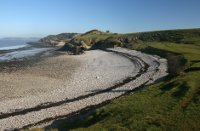
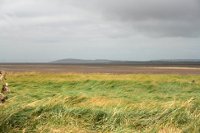
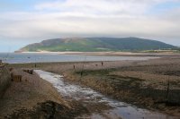
| This walk follows the coast as much as possible between Uphill and Brean. The first part of the walk is alongside the river Axe and roads leading to Brean. The second part of the walk is along the beach at Brean north to and over Brean Down offering wonderful views. The walk ends by continuing south on the beach to Brean.
|
|
 |
 |
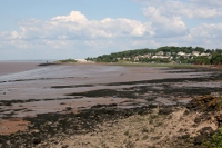
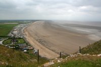
| This is a walk of two halves, the first following the expansive sandy beaches from Brean south to Berrow and the small resort of Burnham-on-Sea. From Burnham-on-Sea to continue along the coast we must first cross the river Parrett which requires diverting inland to Bridgwater. This walk begins to do that by continuing south into Highbridge, crossing the river Brue and then heading south alongside the river Parrett. This part of the walk follows a path over salt marsh and farmland to end in the quiet village of Pawlett, just north of Bridgwater. |
|
 |
 |
| This walk follows the Somerset Coast as much as possible as the River Parrett needs to be crossed and the lowest crossing point is on the northern edge of Bridgwater, requiring a long diversion along the river bank, which makes up this walk. The walk begins from Combwich on the western side of the river and heads along the south bank of the river to the north edge of Bridgewater and crosses the A39 bridge, then continues on the eastern side of the river to Dunball and on to Pawlett. |
|
 |
 |
This walk is a walk of two halves. The first is along the West Somerset Coast path to it’s end at the mouth of the River Parrett and the second part of the walk is along the River Parrett trail beside this river to the village of Combwich. It is worth noting that works is underway to create a new area of marsh on the river Parrett so the paths here are likely to be disrupted. |
|
 |
 |
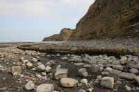
This walk follows the West Somerset Coast path for much of it's length along this attractive and varied coastline. The walk begins from Stogursey and follows an inland route along roads and paths to Hinkley Point where we then head west along the beautiful coastline as it becomes more rugged as we head further west. The walk ends in the pretty town of Watchet. Note that because the West Somerset Coast path runs inland from the coast for part of it's length this walk has some beach walking on rocky and pebble beaches which is hard going and not possible at high tide. Check tide times carefully or follow the main coast path. |
|
 |
 |
This walk takes in the western part of the West Somerset Coast Path along a spectacular stretch of coastline which heads through the hills on the edge of Exmoor and passes the pretty village of Dunster. The first part of the walk is hilly but the latter is flat. |
|
 |
 |
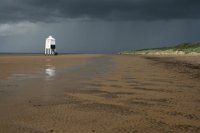
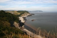
This walk is the first (or last) on the South West Coast Path. It begins in the resort of Minehead with its sandy beach and harbor and soon climbs through woodland into the Exmoor National Park. Here the route follows the heathland and moorland westwards a short distance away from the coast and then descends to the village of Bossington at the eastern end of Porlock Bay. You continue west beside newly-formed salt marshes to finish at the little village of Porlock Weir at the west of Porlock Bay.
Much of the path is across Exmoor. You should be aware that like many moorland areas the weather can be variable and can change quickly so ensure you carry appropriate clothing and wear suitable footwear. |
|
 |
 |
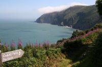
This walk covers much of the spectacular Exmoor coastline. It begins from the town of Lynmouth in a deep valley of the river Lyn and immediately climbs east along the spectacular cliffs, past the lighthouse at Foreland Point and continuing around Contisbury Cove. The walk soon enters woodland that covers the top of the cliffs and continues east through the quite woodlands passing the tiny Culbone church and coming into Porlock Weir to the western edge of Porlock Bay. The walk continues to finish in the village of Porlock a short distance inland. |
|
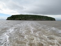
Somerset has a single off-shore island, Steep Holm Island.