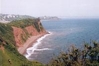
The South Devon section is a varied part of the path. The white chalk cliffs of Beer, rapidly change to high red cliffs leading into Torbay and the English Riviera, one of Britain's best known resorts. Further west, the South Hams offer some of the best beaches in Devon. This section takes you through some remote areas of the path as well as the commercial centres of Plymouth and Torquay.
 |

|
|
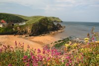
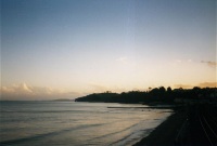
This walk begins in the popular maritime town of Dartmouth. The walk follows the river out to Dartmouth Castle and the coast before rounding the corner and heading towards Stoke Fleming. After Stoke Fleming the path brings you to the good beach at Blackpool Sands. Once through Strete the path joins Slapton Sands where you can then walk along the beach all the way to Torcross. |
|
 |
 |
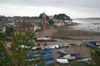
| This is a long walk from the fishing port of Brixham at the south of Torbay, past the famous cliffs of Berry Head to the maritime towns of Kingswear and Dartmouth on the banks of the river Dart. |
|
 |
 |
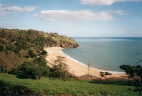
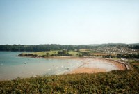
| This walk starts in the popular resort of Paignton, passing it's pier and harbour and the good beaches at Goodrington and Broadsands. From Broadsands the path goes into countryside, passing the quiet and attractive Elberry Cove before emerging into the busy harbour at Brixham. |
|
 |
 |
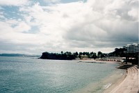
| This is a walk linking Torbay's biggest resorts, Torquay and Paignton. Starting from Torquay harbour the path passes the mariners of Torquay and the sandy beach at Torre Abbey Sands continuing on into Paignton with it's wide sandy beach and pier, a traditional British seaside resort. |
|
 |
 |
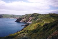
| This walk starts in the bustling resort of Torquay, at the north of Torbay. Despite going through a built-up area, this walk offers some excellent unspoilt scenery and only a little road walking. The walk climbs out of the harbour over Daddyhole Plain before descending again to the beach at Meadfoot beach. There is another climb out of Meadfoot beach up the spectacular viewpoint over Thatcher Rock, then round to Hopes Nose. Once round Hopes Nose the path continues round Anstey's Cove and Redgate Beach over Babbacombe downs and into Babbacombe itself, where there is a cliff railway down to the beach at Oddicombe Beach. |
|
 |
 |
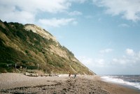
| This walk starts in the popular resort of Teignmouth. Crossing the river Teign to Shaldon, there is a very steep climb to the cliff top, and many hills after that, although there are stunning views around the coast from the cliff top. The path flattens out a little towards to Babbacombe. There are good beaches at Teignmouth, Ness Cove (Shaldon), Maidencombe and Oddicombe. |
|
 |
 |
| This is a short walk linking two of the most popular resort in South Devon. From Dawlish the path initially follows the sea wall alongside the railway and then climbs initially along minor roads and soon to the coast, offering good views around Lyme Bay. After a brief stretch alongside the busy A379 the walk re-joins the sea wall beside the railway line into Teignmouth.
|
|
 |

|
|
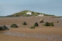
This walk starts in the popular resort of Dawlish. From here it is a flat walk along the sea wall adjacent to the Great Western railway, past the Red Rock, to Dawlish Warren. Dawlish Warren has a popular beach and a nature reserve, sticking out across the mouth of the Exe estuary, it is possible to walk right to the end, where there are good views of Exmouth and the East Devon coast. |
|
 |

|
|
Although much of this walk is not officially on the coast path, it is a scenic and quite easy walk. Starting from the historic city of Exeter, this walk follows the Exe Valley Way alongside Exeter Canal and the River Exe. As you head out of Exeter, the river becomes wider, opening into a large estuary as it approaches the sea. The path passes Powderham Castle before joining the official coast path at Starcross. From Starcross it is an easy walk to the popular resort of Dawlish Warren, passing Cockwood Harbour on the way. |
|
 |

|
|
Although not part of the South West Coast path itself, the new Exe Estuary trail provides a good quality walking route on both sides of the Exe estuary up to Exeter and back. This walk covers the east side of the coast from Exeter to Exmouth via Topsham. From Exeter the walk heads alongside the river through parks and pleasant suburbs to the Countess Wear bridge, the lowest crossing of the Exe it is possible to make on foot. From here we pass through the pretty village of Topsham, cross the river Clyst and continue to the village of Lympstone. From here the rest of the walk is beside the tidal estuary to reach the coast and coast path at Exmouth. |
|
 |
 |
|
This walk starts in the popular seaside resort of Exmouth. Exmouth has a large sandy beach and a busy shopping centre. This walk takes you along the sea front of Exmouth, past Orcombe point to the popular beach at Sandy Bay. From Sandy Bay the path climbs a through fields to the top of the cliffs, and descends slowly through pine trees and gorse to the small town of Budleigh Salterton at the mouth of the river Otter.
|
|
 |

|
|
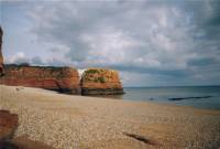
This walk starts in the small town of Budleigh Salterton and takes you along the edge of the pretty river Otter, to a small crossing. From there it's a short walk back to the coast, giving views around the coast. Then descend to the spectacular Ladram Bay with two red stacks of rock. Then it's a steep climb through some woods, before descending via Jacobs Ladder into the popular resort of Sidmouth. |
|
 |

|
|
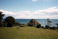
The popular resort of Sidmouth is the starting point for this walk. Sidmouth has a good beach, some spectacular cliffs and hosts a popular Folk Festival each year. This walk climbs the steep cliffs to the East of Sidmouth passing through the pretty village of Branscombe before rounding the white chalky cliffs at Beer Head and into the village of Beer. Beer is a pretty village with white cliffs, unusual for the South Devon coast. |
|
 |

|
|
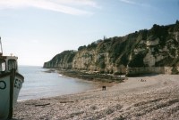
This walk starts in the pretty village of Beer, with the White Cliffs, unusual for Devon. The walk then passes through the resort of Seaton before entering the Dowlands Landslip. This area is now a wood, but was the sight of a massive landslip. This part of the path is remote, with very limited views out to sea. The path comes out of the landslip a little to the west of the popular resort of Lyme Regis in Dorset. |
|